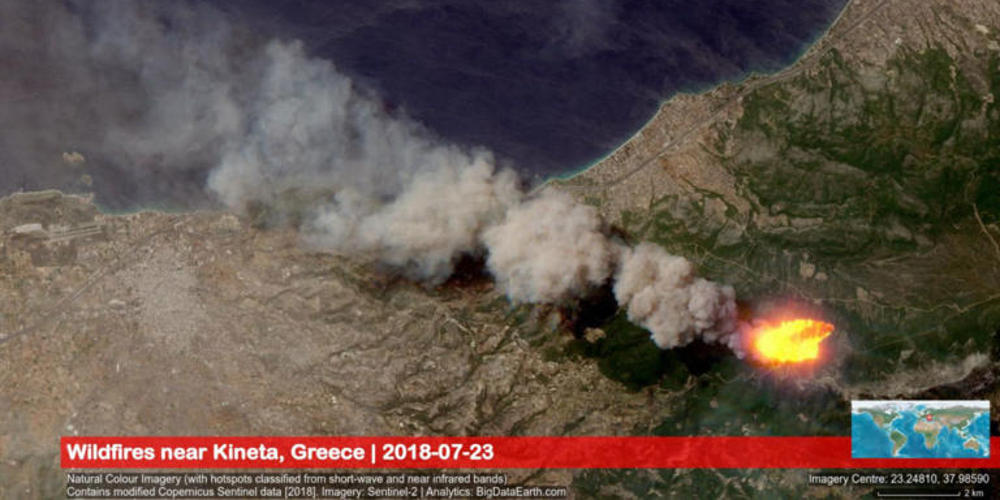
Εικόνες που κόβουν την ανάσα δημοσίευσε η ευρωπαϊκή υπηρεσία Copernicus δείχνοντας την φωτιά στην Κινέτα η οποία ήταν ορατή από το διάστημα
Η υπηρεσία Copernicus καταγράφει τα καιρικά φαινόμενα και τις καταστροφές στην Ευρώπη από το διάστημα. Την Δευτέρα κατέγραψε συγκλονιστικές εικόνες από τη φωτιά στην Κινέτα.
Όπως ανέφερε σε ανάρτησή της στο twitter, το θερμικό φορτίο ήταν τόσο μεγάλο που σε ορισμένες από τις λήψεις του δορυφόρου Sentinel-2 μοιάζει με μεγάλο υπέρυθρο σημείο!


Copernicus EU@CopernicusEU
Our thoughts are with those affected by the #wildfires in Greece

The images we posted yesterday are not from the deadly fire, but from one west of #Athens#Sentinel2 will only make an overpass over the worse hit area, #Marathon/Nea Makri, tomorrow#πυρκαγιών #φωτια #αττικη
11:52 AM - Jul 24, 2018
99
94 people are talking about this
Twitter Ads info and privacy


BigData Earth@BigDataEarth
Devastating #wildfires near #Kineta, #Greece observed by the new #Sentinel2 imagery on 23 July 2018
1. The use of image band combinations to observe fire front & hotspot
2. Climate-warming trend for the region
Thank you @CopernicusEU @ESA_EO for the excellent EO imagery source!
12:13 PM - Jul 24, 2018
35
65 people are talking about this
Twitter Ads info and privacy


Δεν υπάρχουν σχόλια:
Δημοσίευση σχολίου